


Description
North Bradshaw Footprints DVD – $79.95
The BEST Summertime prospecting goldfields in Arizona are in the Bradshaw Mountains near Prescott.
Lynx Creek, Big Bug, Walker, Groom Creek, Poland Junction and the Upper Hassayampa mining districts are all mapped in detail on this FootPrint.
We cover over 200 square miles of some of the most productive gold territory in the country. Detailing over 600 Mineral Patents granted between 1874 and 1962 proves the mineral wealth of these mountains. Many of these patents are now open to prospecting and claiming as part of the Prescott National Forest.
Lynx Creek is the most productive placer creek in the history of Arizona mining. This FootPrint maps the entire creek drainage, including the Lynx Creek Withdrawal Area, the popular public prospecting site that still produces good gold and is workable all year long.
Patents & History
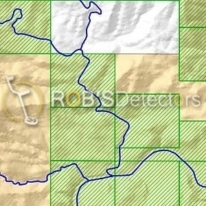
In the area covered by this FootPrint we detail over 700 Patents. Including Homesteads, Mineral Placer, and Mineral Lode Claims.
There is a wealth of easily accessible historical data about mining in the Bradshaw Mountains. Knowing the locations and names of mineral patents allows you marry the history of the area with the map Doing this can provide valuable insights as to where the gold may lie.
We provide a custom map layer, showing the boundaries of all Land Patents in the area along with a database that tells you if the mineral rights were transferred with the patent. An actual copy of the patent is provided where available.
Geology
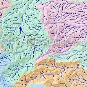
The Bradshaw Mountains have a complex geology. This FootPrint maps the Geology of the entire area at a scale 1:100k, clearly identifying numerous mineralized belts where gold is likely to be found.
Combining the Geology layer with the Hydrography layers will help you identify those downstream areas most likely to contain placer gold.
The complete USGS Geologic Report is included with the FootPrint for extended research.
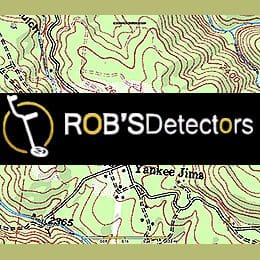
Mining Claims
As with all of our FootPrints, we map all claims to their Actual Boundaries as filed with the County Recorder. The land covered by the North Bradshaw FootPrint is mostly within the boundaries of the Prescott National Forest and open to mineral entry.
There are still thousands of acres of good prospecting areas available for claiming identified on this FootPrint.
Additional information
| MPN | NPN119 |
|---|---|
| Brand | Footprints |
You must be logged in to post a review.
Reviews
There are no reviews yet.